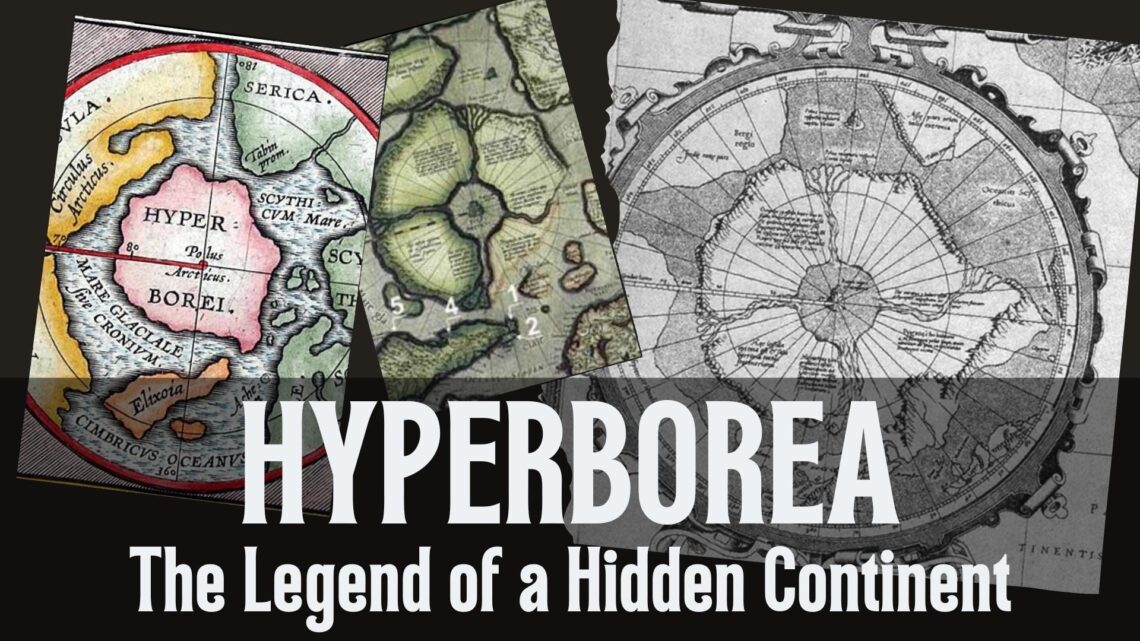
Hyperborea – The Legend about a hidden Continent
Does Hyperborea, the mythical land that appears in various contexts of ancient Greek mythology, literature and music, exist?
Hyperborea is described as a legendary land that exists far to the north. In Greek mythology, it is seen as a place beyond the North Wind, where the “Hyperboreans” lived. This region is often associated with special properties and mystical elements. Furthermore, Hyperborea has found resonance in modern literature, music and pop culture, with artists and authors taking up the concept and interpreting it in their works.
Who is Abraham Ortelius?
Abraham Ortelius was born in Antwerp in 1527. He studied mathematics, Greek and Latin and traveled throughout Europe. He traded in books and was passionate about drawing maps. His first notable map was a world map on eight fold-out sheets in 1564, of which only three copies still exist. In 1570, he published the Theatrum Orbis Terrarum, the first modern atlas with maps of the same size, even though the word atlas was not used by Mercator until 20 years later.
His career as a bookseller and engraver also began in Antwerp before he turned to cartography. He was influenced by the work of Gerardus Mercator, another famous cartographer, and the two became rivals in the field of cartography.
Ortelius’ Theatrum Orbis Terrarum was the seminal work in cartography at the time, as it was the first atlas to be published in a standardized format and contained a uniform series of maps. The atlas contained maps of the whole world, from Europe, Asia, Africa to America, as well as maps of individual countries and regions, but also that of a so-called 7th continent.
Ortelius’ work had a significant influence on the development of cartography and helped to establish the atlas as the standard format for the presentation of geographical information. His work is still highly regarded and his maps are considered to be among the most accurate and detailed of their time.
Most of the maps in the Theatrum were subsequently engraved by Frans Hogenberg, resulting in the most expensive book ever printed at the time. Nevertheless, the undertaking was a great success: by 1612, more than 7000 copies had been printed in six languages and in countless editions. In addition to the Theatrum, Ortelius also revised historical maps, which were attached to the Theatrum or published separately from 1579 onwards. Interestingly, this modern and most detailed atlas in the world at the time included the country of Hyperborea.
Who is Gerardus Mercator?
Gerardus Mercator (1512-1594) was a Flemish cartographer, philosopher and geographer who is best known for creating the Mercator projection. The Mercator projection is a cylindrical map projection that was first published in 1569 and is still widely used today.
This is because the Mercator projection allows for a more accurate representation of the spherical earth on a flat surface, making it easier to navigate and explore the world, which can be found in any altlas. Mercator’s work as a cartographer and geographer had a significant influence on the development of cartography and navigation. He was a pioneer in the use of mathematical techniques to produce accurate maps and helped to establish cartography as a scientific discipline.
Mercator’s most famous work is his world map of 1569, which uses the projection system he developed. The map was a huge success in cartography and helped to establish Mercator as one of the most important and influential cartographers of his time.
His most famous atlas, from 1595, is still known today as “Atlas sive cosmographicae meditationes de fabrica mundi et fabricati figura”, and was another groundbreaking publication in cartography. It helped to establish the atlas as the standard format for the presentation of geographical information. He also mapped a 7th continent with the name: Hyperborea.
Hyperborea – The Land of the Gods
Today, Hyperborea is considered a legend, a mythical land inhabited by a giant race. Back in the 16th century, however, it was not a legend, but a real continent far to the north. For the Greeks, powerful beings lived there, in the land “beyond the north wind”. Pindar, a Greek poet, described the otherworldly perfection of the Hyperboreans in vivid detail.
Greek historians were convinced that Boreas, the god of the north wind, lived in a land called Thrace, and Hyperborea was a region far north of Thrace. According to Pausanias, “the people of the land of the Hyperboreans lived outside the homeland of Boreas”.
Hecataeus of Abdera also described how the Hyperboreans erected a magnificent sacred precinct of Apollo and a remarkable spherical temple decorated with many motifs on their land. The Greek lyric poet Alcaios (600 BC) also sang of Apollo’s actual or mystical journey to the land of the Hyperboreans.
Madame Blavatsky, the founder of the Theosophical Society, claimed that the “second root race” originated in Hyperborea before the later races of Lemuria and Atlantis. The earliest source that mentions the mighty land of the Hyperboreans in detail is found in Herodotus’ “Histories” (Book IV, Chapters 32-36) from around 450 B.C. Although Hyperborea’s description appears in Herodotus’ Histories (Book IV, Chapters 32-36), the Greek author recorded three earlier sources mentioning the Hyperboreans, including Hesiod and Homer, the latter of whom supposedly wrote about Hyperborea in his lost work Epigoni.
Where is Hyperborea located?
The descriptions of Hyperborea suggest that it was a perfect land where the sun shone twenty-four hours a day. During the midnight sun period of the year, the sun remains visible at midnight. This description has led some authors to suggest that Hyperborea may have been a land area mentioned in antiquity that was located somewhere within the Arctic Circle.
Herodotus also wrote that the 7th century BC poet Aristeas wrote about the Hyperboreans in a now lost poem called Arimaspea, about a journey to the Issedonians, who presumably lived in the Kazakh steppe. However, Hyperborea was mentioned in the fifth century BC by a number of Herodotus’ contemporaries, including Pindar, Simonides of Keos and Hellanicus of Lesbos.
On this map from 1570, Hyperborea is depicted as an Arctic continent far to the north and described as “Terra Septemtrionalis Incognita” (Unknown Northern Land):
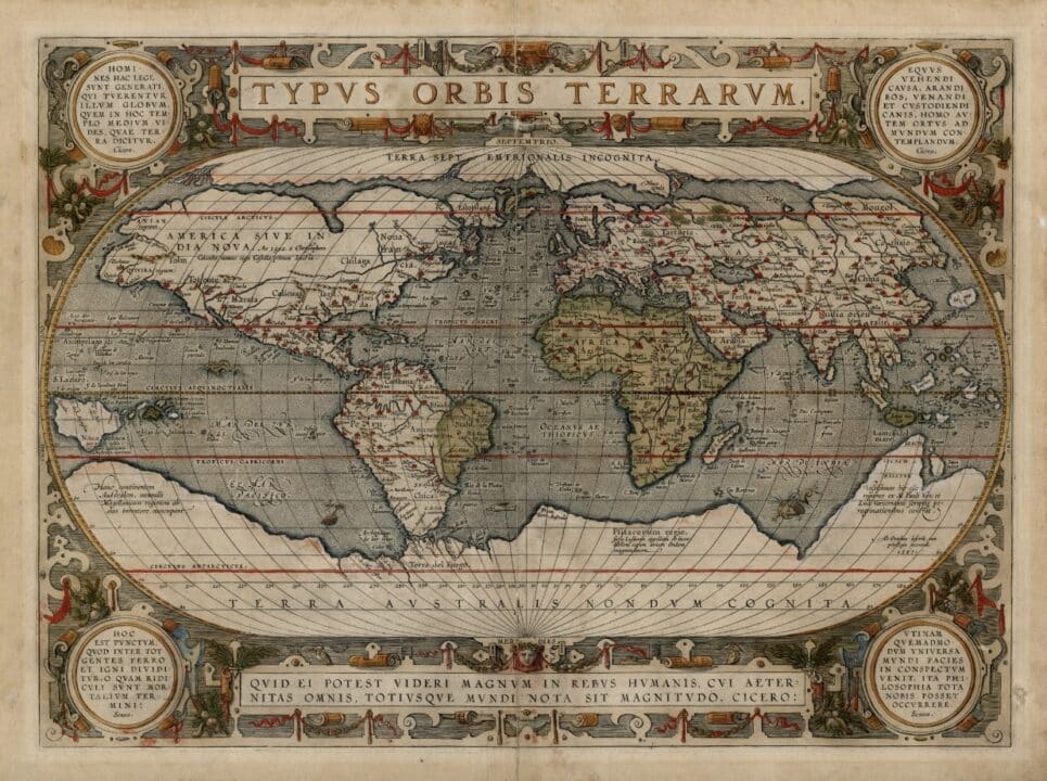
In Greek mythology, as this period is known today, the Thracians existed far to the north. Their origin was the land of Hyperborea, a northern island in the Arctic Circle.
Diodorus once explained: “In the regions beyond the land of the Celts lies an island in the ocean, no smaller than Sicily. This island lies to the north and is inhabited by the Hyperboreans, so called because their home is beyond the point from which the north wind (Boreas) blows; and the island is both fertile and productive of every kind of grain and has an unusually temperate climate.”
H.P. Blavatsky, Rene Guenon, Lokmanya Tilak and Julius Evola shared the knowledge of the Hyperborean, polar origins of mankind. According to them, Hyperborea was the polar center of the Golden Age of civilization and spirituality. They say, “Humanity did not once rise from the ape, but is gradually evolving into the ape-like state as it moves physically and spiritually away from its mystical otherworldly home in the far north and succumbs to the demonic energies of the South Pole, the greatest point of materialization.” (see: Joscelyn Godwin, Arktos: The Polar Myth)
Hyperborea is also known as Svarga or Blue Svarga from Indian and Slavic legends. In ancient Indian and Buddhist texts it is also referred to as “Jambudvipa”.
Hyperborea – Northern Home of the Humans
Many maps exist today. On almost all of them, the regions around the poles are not included at all. Many have simply colored in white what Antarctica really shows or should at least indicate, and that’s it. Similarly, Google Maps, which tens of millions of people use every day, only shows white areas at the poles and claims that there is only snow there and it is boring, so hardly worth a visit. But is that true?
Fortunately, there were once such maps, albeit not so many, on which the 7th continent – Hyperborea – was also depicted. Perhaps the most famous and detailed of these depictions is the Mercator map of the North Pole:
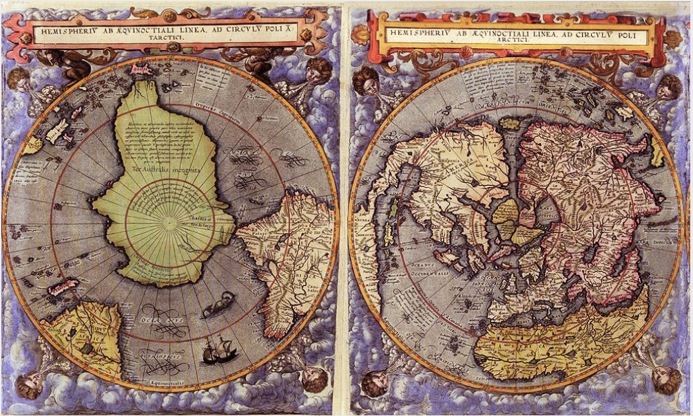
The old cartographers had the very useful habit of not only describing their maps with the names of geographical features, but also adding short descriptions of the places depicted. Mercator also did this on his famous map.
However, these are not the only depictions of Hyperborea on old maps. Some time ago we mentioned the maps of Piri Reis, who depicted the unfrozen coast of the southern continent quite accurately in the 16th century.
But let’s take a look at a few more examples…
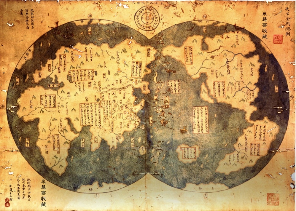
This map shows that, compared to most European cartographers, the Chinese already had a fairly accurate idea of the distribution and shape of the continents at the beginning of the 15th century (and Columbus wasn’t even born yet!). You can even discover some areas here that we have no idea about even in the 21st century. And it’s not just Hyperborea.

So many randomly selected old maps whose authors were convinced that there was more than just ice and snow at the North Pole. However, the maps stored here are likely to have been largely preserved, as they provided very valuable data for contemporary seafaring and were therefore of great commercial and, above all, military importance.
By the way, has anyone noticed that Gerard de Jode, for example, drew the outline of Antarctica almost exactly as Google Earth shows it to us today from an altitude of 10,000 kilometers? And Jode drew this map at the end of the 16th century, when the entire area is said to have been covered by huge masses of ice and snow.
The opinions of current scientists are almost unanimous that all European nations could have a common origin. The Greeks called it Hyperborea, the Slavs Daar-ia, the British Avalon, the Germans Thule, the Indians and Irish Arianna and so on.
Did Hyperborea really exist or not?
Mercator and some other ancient cartographers seem to have been aware of this.
According to many descriptions, there was a small island in the middle of Hyperborea, on which rose the mythical Mount Meru, the seat of the gods and the navel of the world, the holiest of all mountains. It was also the location of the exact North Pole. The top of the mountain was transformed into a pyramid shape and all newly built pyramids in the world were aligned with its specifications.
At the tip of the North Pole, the three and a half thousand meter high peaks of the Lomonosov Mountains rise from the seabed and reach another thousand meters to the surface. It doesn’t look like a sunken island.
As you can see, Hyperbora fits in well with the area around Greenland and North America. The waterway that runs down from the center of Hyperborea follows the exact line of the west coast of Greenland, the Baffin Sea region and the Davis Strait. The mouth of this river lies appropriately in the bay of the Labrador Sea. The waterway leading to the right ends at the mouth of the rivers that flow into the fjords in the land of King Christian the X, between Cape Bruster and Traill Island.
On Mercator’s map, Hyperborea almost completely touches the neighboring country at this point, which is referred to as “ASIAE PARS”. On the actual map of the seabed, the outline of this country corresponds exactly to the outline of the north of the Eurasian Plateau.
Again, one might almost think that artographic materials of this kind could only have been obtained using a flying vehicle, sophisticated technologies and the use of powerful computer equipment to create specific projections (spherical trigonometry). And medieval cartographers, as we know, did not have such means at their disposal.
The Strategy of the Flight Routes of our Time
Now comes the big question: does Hyperborea really exist or did it once sink and since its sinking has only been part of ancient legends?
Since the maps were largely created in the 16th century, this would be an indication that Hyperborea did not sink, because the Great Flood, for example, was well before that time. Or did these navigators and cartographers simply use ancient maps and simply copy them or were they, in their time, up-to-date maps? But what if not, what if the land of Hyperborea still exists today?
In this case, it has probably been withheld from the humanity of our time, pretending that there is no more land and continents than those that can be found on Google Maps or in current atlases. But how could this be concealed at a time when airplanes exist?
Quite simply! There must be agencies and authorities that coordinate the flight routes of all airplanes worldwide and design their routes so that they fly around the secret land masses.
Here you can see the globally coordinated and legally (!) defined flight routes, which are determined and organized by several agencies worldwide and passed on to all airports:
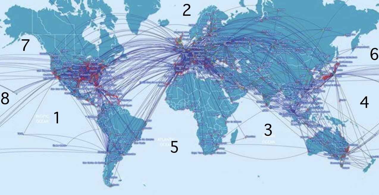
Airplanes always have to fly in a high arc to their destination because they have to take the earth’s rotation into account, otherwise they would miss their destination. Flights from right to left are shorter, while flights from left to right take longer. This is also the case because the earth always rotates in a certain direction. If you look at this map with the official flight routes, it would theoretically be possible to systematically fly around secret land masses.
However, the flight routes clearly show that many areas on the world map are not flown over and in fact are not flown over at all. In some cases it is understandable because it would not be a direct flight path or nobody would want to go there, but other areas flown around seem incomprehensible, e.g. areas 1, 3, 4 and also north of 5, as there is no direct connection from Africa to South America in the latter:
Hyperborea could be in area 2. However, flight routes exist not only in area 2, but also in many other places – see the other areas marked with numbers. Area 1 in particular is strictly avoided and flown around in a triangle. The same applies to areas 3 and 4.
Space 5 in general, on the other hand, would still leave plenty of room for land masses, which mankind would only find out about if they had enough billions at their disposal to obtain this secret information.
The Elite have their own Search Engines
Consider the fact that you can always get free information on the Internet and with the popular search engines, and free information is never really accurate. Billionaires have their own search engines, for which they pay millions of dollars a month or more to access secret information at certain levels of classification. The more is invested, the more is revealed.
This must never be forgotten in all your research using free search engines. Most information for the peoples of the world has been deliberately censored and restricted. At present, we are witnessing how censorship is being used to neutralize more and more sources of information. However, censored information is not really neutralized, but only increasingly hidden by the free search engines, i.e. kept secret. In computer language this is called “shadow banning”, in the mainstream “fake news” and colloquially “censorship”.
Summary
Hyperborea could well still exist, if only you realize that the North and South Poles are restricted military areas. As a private individual, you are not allowed to fly over certain latitudes or try to reach random targets at the poles, otherwise you will be stopped by jet fighters and military ships and asked to turn back. If you do not follow this instruction, you will quickly be shot at.
If Hyperborea still exists, then it is only a step to the conclusion that there are perhaps other land masses that are being withheld from the peoples of this world. Quite deliberately and with full intent, and this begins with the coordination of flight routes.
Sources:
The best know maps
Many maps listed here
Curiosmos
Wikipedia Oceanus Hyperboreus
Hyperborea – First Map of the North Pole by Gerardus Mercator
Hyperborean Vibrations Blog
Abraham Ortelius
Ortelius master prints
Ancient Origins
Evolution Human
“The punitive squads: Hyperboreans’ life”, Ales Adamovich (1980)
“Sive Veteris Geographiae Tabulae, Commentarijs Geographicis et Historicis illustratae”, Abraham Ortelius, Theatri Orbis Terrarum Parergon, Balthasaris Moreti, Antwerp, 1624. Gagné (2021: 35) Figure 12. Gerardus Mercator, Septentrionalium terrarum descriptio, Amsterdam, 1623


